Oregon's Coastal Playground
Come and play


Every Second Tuesday Bridgeport Market, Florence, Oregon Join us for monthly wine tasting in Florence, Oregon at Bridgeport Market! Each Second Tuesday features…

Ever wondered how great ideas turn into real, funded businesses? Join us for the first-ever Florence PubTalk, hosted by Cascades West Innovation Hub in…

Florence Oregon Art Class at Serene Abundance Studio Event Details 📅 Date: 2nd Fridays ⏰ Time: 6:00 PM – 8:00 PM 📍 Location: Serene Abundance Studio…

Every Second Saturday | 3:00 PM – 5:00 PM Backstreet Gallery 1421 Bay St Join Backstreet Gallery for the Second Saturday Art Tour Artist Reception, a…

Supporting Transitional Housing for Families in Florence Oregon Date: Saturday, June 13, 2026 Time: 6:00 PM – 9:00 PM Location: Florence Events Center…

Golf-lovers will enjoy a truly unique experience when they take on the links on the Oregon Coast.

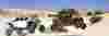
Beaches, Food, Dunes & Unforgettable Coastal Adventures When summer arrives on the Oregon Coast, few places offer as much variety and natural beauty as Florence. Nestled where the Siuslaw River…

Top 10 Things to Do in Florence, Oregon, This Spring Spring is one of the best times to visit Florence, Oregon, and discover why this place is known as Oregon’s Coastal Playground. The weather begins…

How to Craft the Perfect S’more (Florence-Style) Start with the Right Fire The secret begins before the marshmallow ever meets the heat. Whether you’re on the beach or at a cozy campsite near Oregon…

Whale Watching in Florence, Oregon: Your Guide to the Coast’s Seasons of Sublime Grandeur If you’re looking for a reason to visit the Oregon Coast, whale watching in Florence offers one of the…

Learn When Exceptionally Low Tides Are Expected Along Florence Beaches Residents and visitors to the Florence area can look forward to a series of unusually low tides along the beaches in Florence…

Top-25 Family Weekend Getaways With Kids

8 Coolest Cities You Must Experience Yourself
Second-Best Small Town in the Northwest
Most Beautiful Town


